
Showing posts with label Travel-Local. Show all posts
Showing posts with label Travel-Local. Show all posts

Flightradar24 is a flight tracker, that makes it possible to view airplane traffic, in real time, on a Google Map in your Android phone/tablet. Flightradar24 has the best coverage of all flight trackers in Europe and together with many great features, Flightradar24 has become the most popular flight tracker in most countries around Europe.
COVERAGE
Apart from Europe there is some coverage in Russia, USA, Canada, Australia, New Zealand, Greenland, South Africa, Brazil, Argentina, Japan, Hong Kong, Malaysia, India, Maldives, Middle East and some other parts of Asia.
Features:
View full aircraft info, route info and picture of the aircraft.
View flight trails and callsigns directly on map.
Possibility to show airline logos in connection with the aircraft.
Aircraft moving in real time.
Search for flights (flight numbers and call signs).
Emergency squawk notifications.
Filters to view flights from just one airline.
Augmented Reality (AR).
AR VIEW
Augmented Reality makes it possible to point the camera to the sky and view information about air traffic above your head. The AR feature require a GPS and compass to work correctly.
IMPORTANT
Flightradar24 can only track aircraft equipped with an ADS-B transponder. Visit http://www.flightradar24.com/ to get more information about Flightradar24 coverage and ADS-B.
What's in this version : (Updated : Aug 8, 2012)
Several bugs and crash reports fixed!
Required Android O/S : 2.1+
Download : 4.1Mb APK
Screenshots :


Download here:

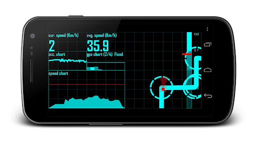
Head-up display (HUD) provides navigation indication on the windshield, in which Driver gets information without move attention away from windshield.
Turn by turn navigation
The navigation instruction is designed to provide better experiences for binding with HUD. Simple notation and signal is the main consideration. Turn by turn speech instruction support (Not all language)
Feasible for different circumstances
NAVIER HUD can be used in driving, biking, jogging…. It can be switched between HUD mode and normal mode and set on vehicle with accessories.
Customize your layout
NAVIER HUD provides many parts, such as compass, routing instruction, average speed, routing progress, moving distance…, which can be used in users’ panel layout. You can select parts and layouts that are fit to your usages.
Sync your data with Google account
NAVIER HUD backup and sync your data (Destination and panel layouts) in multiple devices with bind Google account.
What's in this version : (Updated : Aug 2, 2012)
Turn-by-turn speech instruction is supported in following languages: English, French, German, Italian and Spanish. Other languages need to install extra speech kit (such as SVOX) for speech function.
No ads in premium edition
Data sync is provide in premium edition only
Required Android O/S : 2.1+
Download : 1Mb APK
Screenshots :


Download here:

Use your phone or tablet as an offroad topo mapping GPS with the bestselling outdoor navigation app for Android! Explore beyond cell coverage for hiking, hunting and more.
Download topo maps for the US and some other countries in advance, so you won't need cell coverage when navigating.
This uses many publicly available map sources as free downloads. It also has some additional content available as an in app purchase:
Boundary maps for 12 western states from the Bureau of Land Management(BLM) for $7.99. Great for hunters, hikers, and prospectors.
Content from US TrailMaps for $15.99, including:
Snowmobile Trail Maps for Snowmobiling enthusiasts,
ATV Trail Maps
Whitewater Trail Maps,
Equestrian Trail maps.
See these in the menu under More-> "Purchasing AddOns".
You are welcome to try the DEMO version to make sure you like the maps in your country.
NOTE: If you've already purchased this or any paid app, you can install it at any time from 'My Apps' in the Android Market.
Use offline topo maps and GPS on hiking trails without cell service! The GPS in your Android phone can get its position from GPS satellites, and you don’t have to rely on your data plan to get maps. Have more fun and safe GPS adventures in the backcountry.
Preload offline topo maps, aerial photos, and road maps on your storage card, so they are ready when you need them for your GPS navigation. Many free map source are built into the app.
Add custom GPS waypoints in longitude and latitude, UTM or MGRS grid reference. Import GPS waypoints from GPX files. Choose mapsource-like icons for GPS waypoints. (This app uses the WGS84 datum, NAD27 is available in settings).
Use GPS for hunting a waypoint or geocache, for recording tracks and GPS waypoints on your trip, all the while tracking your GPS quest on topographic maps.
What's in this version : (Updated : Jul 15, 2012)
Enter waypoint or GOTO point by entering coordinates in search bar.
Updates: USGS Aerials now uses National Map
Southern Europe map choices: More resolutions on Italy map.
Faster downloading! Up to ten times as fast.
More reliable selection for downloads.
New Map Source: 4umap: Free Topographic map of Europe
New Map Source: Catalunya
Addons include Accuterra map source,SnowMobile trail maps, ATV, Equestrian, Birding, and Whitewater trail maps, and BLM Land Boundary Maps of 12 western states.
Required Android O/S : 1.6+
Download : 3.2Mb APK
Screenshots :


Download here:
MULTI-FUNCTION TOURIST NAVIGATION Irreplaceable application for hiking, geocaching and your everyday life.
Locus offers many useful features such as :
Online maps (browsing and downloading)
Offline maps
Navigation (online calculation tracks)
Vector maps
WMS service
Track recorder
Integration of Google My Maps (reading and editing)
Geocaching
Parking
Weather service
Point of interest
POI alert
Search (by adress, coordinates, contact)
Custom screen (created by community)
Integration of GPSies, Breadcrumbs, Street View and other
API for developers
Features :
ONLINE MAPS
OpenStreet maps (16 types), Freemap (4 types), ArcGIS (4 types), SHOCart (4 types), MapQuest (3 types), Navigasi (1 type)
Most of the maps can be used in offline mode. Selection of maps is still expanding. If you have a favorite map, which you don't find in Locus, please let us know and we add the maps to Locus (condition is that Locus corresponds with terms of use of map providers).
OFFLINE MAPS
Support for SQLite, TAR maps, MBT maps, GEMF formats.
GEOCACHING – complet offline
Support for import Pocket Query files, Field notes (ability to pre-fill), load all waypoints for all POIs, graphical calculations (intersections of circles, intersection of lines) and many other tools for geocaching.
VECTOR MAPS
Vector maps of the whole World in Locus.
Possibility to easy and fast downloading of maps thanks to addon, which can be bought to Locus Pro for 1€. The biggest advanteges are small size and quality of maps in all scales.
WEB MAP SERVICE – online
The service allows to display map layers (thematic maps) of geographical informations, that are provided for public by individual institutions.
What's in this version: (Updated : Ju1 3 ,2012)
add: possibility to disable "Auto zoom-lock"
chg: highly improved zooming behavior (mainly pinch-zoom)
chg: better selecting of maps when Overlay is enabled
fix: huge CPU usage on Map screen
fix: problems with loading offline Smartmaps maps
fix: duplicate records from Live tracking
fix: many other small fixes
Required Android O/S : 1.6+
Download : 4.4Mb RAR (Use Custom patch to remove license verification)
Screenshots :


Download here:

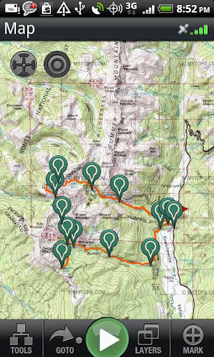
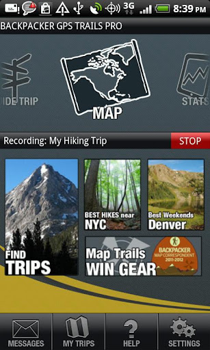
Find hiking trails, view topo maps and navigate with GPS & compass.
Record hiking trails, backpacking trips, and camping adventures with Backpacker GPS Trails Pro. View maps, navigate with GPS and digital compass, take photos, and backtrack to the trailhead.
GPS Trails Pro works in remote places like national parks, wilderness areas, and backcountry spots without relying on data and cell signals.
Features:
Turn your phone into a GPS: Navigate via precise satellite signals in and out of cell network.
Capture waypoints: Mark campsites, trailheads, water sources, summits, and more.
Track every step: Record or follow your tracks and routes. Store unlimited tracks.
Share your trip: Post adventures to backpacker.com, Twitter and Facebook.
Geotag your photos, videos, and sound clips: Save coordinates with every image and see their exact location on a map. Auto-save videos to your YouTube account too.
View maps: See unlimited street maps, aerial photos, hybrid street/aerial maps, and topo maps provided by MyTopo.
Navigate on the trail: Be an expert backcountry navigator. Use the digital compass to follow bearings or go to waypoints on the trail.
Save maps: Store offline topos and other maps on your phone for viewing in remote areas.
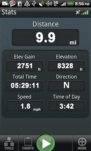
View stats: See 10 stats, including elevation, speed, and distance.
Pick your coordinates: Choose latitude/longitude or UTM and WGS 84 or NAD 27 then use GPS Trails for advanced navigation with traditional paper maps.
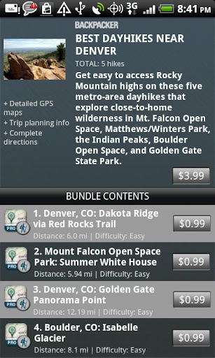
Download Pro Trips: Follow our step-by-step trail guides of popular trails and lesser-known routes in national parks, national forests, and local parks, including Yellowstone, Yosemite, Grand Canyon, Great Smoky Mountains, Glacier, Rocky Mountain, White Mountains, Adirondacks, Catskills, Zion, Arches, Canyonlands, Acadia, Mount Rainier, Everglades, Olympic, and more. Find hikes near major cities: New York City, Seattle, Portland, LA, Denver, Chicago, Boston, Atlanta, and more. Plus find section hikes on the Appalachian Trail, Pacific Crest Trail, and the Continental Divide Trail.
Search trips: Find thousands of trips shared by the Backpacker.com community.
Plan trips: Draw routes with our free web-based map software (backpacker.com/postatrip) or BACKPACKER Map Maker for iPad (backpacker.com/mapmaker), then sync them wirelessly in the Backpacker Trip Cloud.
Upload GPS files: Load your own .gpx files at backpacker.com/postatrip.
Get published: Every month the editors at Backpacker handpick adventures shared by its online community to be published in the magazine. Kickstart your adventure writing and photography career with GPS Trails.
MORE INFO
Supported Phones: GPS Trails Pro is designed and optimized for the Android phones.
Battery Life: While we optimize our code to cut down on power requirements, continued use of the GPS running in the background can dramatically decrease battery life. For longer dayhikes or overnight trips, we suggest packing lightweight battery packs to charge the phone.
Follow Us: We’ve created a Facebook page for our mobile apps to discuss upcoming releases, new features, and your feedback. Your feedback helps us create a better app. Go to: facebook.com/backpackergpstrails.
What's in this version : (Updated :Jun 25, 2012 )
Added location search on the map screen
Added OpenStreet and OpenCycle map types
Fixed a crash when sharing a trip to Facebook via the quick action menu
Various bug fixes
Required Android O/S : 2.1+
Download : 6.5Mb APK
Screenshots :
Download here:
Use your phone or tablet as an offroad topo mapping GPS with the bestselling outdoor navigation app for Android! Explore beyond cell coverage for hiking, hunting and more.
Download topo maps for the US and some other countries in advance, so you won't need cell coverage when navigating.
This uses many publicly available map sources as free downloads. It also has some additional content available as an in app purchase:
Boundary maps for 12 western states from the Bureau of Land Management(BLM) for $7.99. Great for hunters, hikers, and prospectors.
Content from US TrailMaps for $15.99, including:
Snowmobile Trail Maps for Snowmobiling enthusiasts,
ATV Trail Maps
Whitewater Trail Maps,
Equestrian Trail maps.
See these in the menu under More-> "Purchasing AddOns".
You are welcome to try the DEMO version to make sure you like the maps in your country.
NOTE: If you've already purchased this or any paid app, you can install it at any time from 'My Apps' in the Android Market.
Use offline topo maps and GPS on hiking trails without cell service! The GPS in your Android phone can get its position from GPS satellites, and you don’t have to rely on your data plan to get maps. Have more fun and safe GPS adventures in the backcountry.
Preload offline topo maps, aerial photos, and road maps on your storage card, so they are ready when you need them for your GPS navigation. Many free map source are built into the app.
Add custom GPS waypoints in longitude and latitude, UTM or MGRS grid reference. Import GPS waypoints from GPX files. Choose mapsource-like icons for GPS waypoints. (This app uses the WGS84 datum, NAD27 is available in settings).
Use GPS for hunting a waypoint or geocache, for recording tracks and GPS waypoints on your trip, all the while tracking your GPS quest on topographic maps.
What's in this version : (Updated : Jun 21, 2012)
PLEASE update to 4.5.7 as soon as the Market will let you- there was a problem with 4.5.6.
Faster downloading! Up to ten times as fast.
More reliable selection for downloads.
Fix for crash after closing trip file.
Everytrail API version 3.
New Map Source: 4umap: Free Topographic map of Europe
New Map Source: Catalunya
Addons include Accuterra map source,SnowMobile trail maps, ATV, Equestrian, Birding, and Whitewater trail maps, and BLM Land Boundary Maps of 12 western states.
Required Android O/S : 1.6+
Download : 3.2Mb APK
Screenshots :

Download here:
MULTI-FUNCTION TOURIST NAVIGATION Irreplaceable application for hiking, geocaching and your everyday life.
Locus offers many useful features such as :
Online maps (browsing and downloading)
Offline maps
Navigation (online calculation tracks)
Vector maps
WMS service
Track recorder
Integration of Google My Maps (reading and editing)
Geocaching
Parking
Weather service
Point of interest
POI alert
Search (by adress, coordinates, contact)
Custom screen (created by community)
Integration of GPSies, Breadcrumbs, Street View and other
API for developers
Features :
ONLINE MAPS
OpenStreet maps (16 types), Freemap (4 types), ArcGIS (4 types), SHOCart (4 types), MapQuest (3 types), Navigasi (1 type)
Most of the maps can be used in offline mode. Selection of maps is still expanding. If you have a favorite map, which you don't find in Locus, please let us know and we add the maps to Locus (condition is that Locus corresponds with terms of use of map providers).
OFFLINE MAPS
Support for SQLite, TAR maps, MBT maps, GEMF formats.
GEOCACHING – complet offline
Support for import Pocket Query files, Field notes (ability to pre-fill), load all waypoints for all POIs, graphical calculations (intersections of circles, intersection of lines) and many other tools for geocaching.
VECTOR MAPS
Vector maps of the whole World in Locus.
Possibility to easy and fast downloading of maps thanks to addon, which can be bought to Locus Pro for 1€. The biggest advanteges are small size and quality of maps in all scales.
WEB MAP SERVICE – online
The service allows to display map layers (thematic maps) of geographical informations, that are provided for public by individual institutions.
What's in this version: (Updated : Jun 13 ,2012)
add: Improved track editor (cutting of start/end track parts, inserting new points, ...)
add: Drag and drop system for "Quick new point" feature (for A3.0+)
add: Improved filter system in "Tracks screen"
chg: improved design of "Points screen" and removed "Category" icon from Data manager
fix: some problems with incorrect icons for POIs
fix: issue with WMS maps and scale resolution
fix: problems with access to Locus Shop
fix: many small reported problems
Required Android O/S : 1.6+
Download : 4.4Mb RAR (Use Custom patch to remove license verification)
Screenshots :
Download here:

Use your phone or tablet as an offroad topo mapping GPS with the bestselling outdoor navigation app for Android! Explore beyond cell coverage for hiking, hunting and more.
Download topo maps for the US and some other countries in advance, so you won't need cell coverage when navigating.
This uses many publicly available map sources as free downloads. It also has some additional content available as an in app purchase:
Boundary maps for 12 western states from the Bureau of Land Management(BLM) for $7.99. Great for hunters, hikers, and prospectors.
Content from US TrailMaps for $15.99, including:
Snowmobile Trail Maps for Snowmobiling enthusiasts,
ATV Trail Maps
Whitewater Trail Maps,
Equestrian Trail maps.
See these in the menu under More-> "Purchasing AddOns".
You are welcome to try the DEMO version to make sure you like the maps in your country.
NOTE: If you've already purchased this or any paid app, you can install it at any time from 'My Apps' in the Android Market.
Use offline topo maps and GPS on hiking trails without cell service! The GPS in your Android phone can get its position from GPS satellites, and you don’t have to rely on your data plan to get maps. Have more fun and safe GPS adventures in the backcountry.
Preload offline topo maps, aerial photos, and road maps on your storage card, so they are ready when you need them for your GPS navigation. Many free map source are built into the app.
Add custom GPS waypoints in longitude and latitude, UTM or MGRS grid reference. Import GPS waypoints from GPX files. Choose mapsource-like icons for GPS waypoints. (This app uses the WGS84 datum, NAD27 is available in settings).
Use GPS for hunting a waypoint or geocache, for recording tracks and GPS waypoints on your trip, all the while tracking your GPS quest on topographic maps.
What's in this version : (Updated : Jun 8, 2012)
New Map Source: 4umap: Free Topographic map of Europe
New Map Source: Catalunya
Kml Import fixes
Customize GPS Pointer Color
Turn individual tracks on/off.
Accuterra topo maps, multilayer US map source, added as purchasable upgrade.
Addons include Accuterra map source,SnowMobile trail maps, ATV, Equestrian, Birding, and Whitewater trail maps, and BLM Land Boundary Maps of 12 western states.
Required Android O/S : 1.6+
Download : 3.2Mb APK
Screenshots :
Download here:

